Posted by baad lamb
When flying, I always want the window seat. Then I hope for clear skies the full length of my trip. On my most recent flight south, to recharge with The Father of Perpetual Leisure (AKA my huzbind), the sky was unfortunately hazy for the first hour, then completely immersed in thick pearl-gray clouds until inches from the Ft. Lauderdale runway. This was especially disappointing because the totally saturated South Florida suburban sprawl, so soul-crushingly dull when experienced on the ground, is actually endlessly entertaining when viewed from the air.
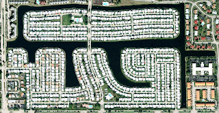
My layman’s guess as to the reason for the maze-like sameness to this development is that the high water table and the relentlessly flat earth essentially requires developers to divide their parcels into almost equal amounts of mounded dirt and channeled water. This sets down the basic parameters that send the site planners and landscape architects on their creative competition for best alien aircraft attractors.
Like the mysterious Nazca Lines in southern Peru, the only way to fully appreciate this creativity is from the air. The man-made divisions and color contrast between land and water are clearly seen, then these outlines are decorated by the size, shape and placement of the buildings, their roof colors literally the icing on the cake.
Today, the instant access to various virtual earth satellite photos allows even greater scrutiny (power up Google Earth and spend so much time exploring you can kiss today good-bye). Perhaps this will result in greater site planning creativity in the future (palm-tree shaped islands excluded).
Flying high above, latitude & longitude determine the position of superblocks, which are drawn by major roads, their right angle rigidity occasionally softened by the few remaining natural features – a “real” river or a wind-breaking tree line – but more frequently by the false-meandering of State or Federal highways following their eminent domain plotted course.
The “patchwork quilt” metaphor may work well for flying over farmland and rural areas, but gliding above Broward County, I like to think of a giant tile floor that has been assembled and grouted by an aging Cuban craftsman. His years of skill assure perfectly aligned pieces, as even and flat as they are parallel. But his eclectic taste, combined with late-in-life-poor eyesight has produced a remarkably varied design, as if each piece was selected from different boxes and different manufacturers.
When seen from 10,000 feet, this combination of precision skill and random design seems coherently similar, spread across the landscape with fractal predictability: not exactly the same, not obviously different.
After cut’n & paste’n these satellite photos, my mind starts down its own fractal path. Who (or better still, how many) can claim ownership of these pictures? Certainly Google, since we all know they own the “Earth”. But: a satellite, guided by human produced software originally took multiple preliminary photos. These photos were then enhanced, color corrected and pieced together by another computer/software combination. No doubt the final photo would have to be approved by some hybrid designer/cartographer/art director, and even this “final” photo is updated periodically.
Meanwhile, down on the ground, a developer with money and an idea hired a site planner, an architect, and a landscape architect. Informed by local zoning laws and building codes, they submitted a plan where lot coverage, building heights, mass, setbacks and sometimes, even materials were pre-determined by these codes. Usually, a Design Review Board weighs in, changing colors, textures, finishes and plantings as they deem correct.
Then, when everything is finally built, from the comfort of my armchair - or discomfort of my coach fare - I frame a shot and snap a photo, crop it to only what I want, and enhance the color and contrast as I deem correct. It may not be art, or even original, but the process and the results make for an entertaining diversion during a foggy flight.
This is the time, and this is the record of the time...
This is the time, and this is the record of the time...


This is what I call home. (Not Dade/Broward, but Sarasota. From the air, strikingly similar.) This beautiful collection of amoebas, bacteria, and diatoms from the air certainly loses its cachet on the ground. It's the old untouched Florida that will take your breath away.
ReplyDeleteFind your way to the land that we've left alone: live oaks, palmettos, cypress, pines, moss-draped swamps, insects, birds, snakes and alligators. The humid heat becomes a second skin. The dappled light under the massive limbs gives way to searing brightness. The silence that marks the absence of man is filled with the sounds of the land and its occupants. Wild Florida is fading away under pretty manmade designs. Find it while you can.
The state is a giant limestone sponge. Anything that passes for a hill is simply land surrounded by sinkholes. Thunderstorms leave puddles that sink into the underground labyrinth of water in minutes. The afternoon showers cool the land briefly before the steam begins to rise from the streets. The cycle repeats each summer afternoon.
Can you tell I miss it? I'm coming home in a couple of weeks, and I can hardly wait.
Some of these images bring to mind Hawai'ian style quilting, as well.
ReplyDeleteI have spent several cross country flights with my face planted to the window as I watch out nation slip by below me. I sometimes pray for foul weather over Idaho or the rockies so we are forced into a southernly route exposing cayins and desert that melt into the plantings or snows of the plains. Somewhere over Pennsylvania there is a shift in the size and distance between homes so that as one drifts down into JFK or EWR, it unmistakably eastern in its feel.
ReplyDelete